Travel Videos of Australia
  • Home
  • About
  • Our Work
  • Shop
    • Australia
    • Books
    • Bundles
    • Download
    • DVDs
    • International
    • Specials
  • Travel Stories
  • Contact
0
Your cart is empty. Go to Shop.
West of the Stuart Highway, South Australia
07/02/2019

West of the Stuart Highway, South Australia

Anne Morton Australia, South Australia 4wd adventure, 4wd travel, exploring, South Australia 0

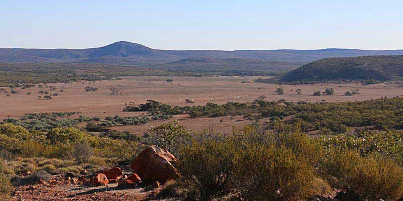
When planning a trip into South Australia most off roaders think of the Flinders Ranges, Simpson Desert or the great tracks – the Oodnadatta, the Birdsville and the Strzelecki. But there is plenty of adventure to be found to the west of the Stuart Highway as well.

Beginning in Port Augusta our convoy group took the long road to Alice Springs, west of the Stuart Highway and we found diversity in terrain and landscape, from desert sand to coastal sand, salt lakes and flooded rivers, historical events and a different look at the wide brown land.

Iron Knob

First stop was at Iron Knob, approximately 70 kms along the Eyre Highway to the west of Port Augusta. Weaving our way through the township, we finally found the Tourist Centre and Museum, which is as far away from the highway as is possible.

Iron Knob, perched on the slopes of BHP’s iron ore mine of Iron Monarch, is situated prominently with fine views across the flat plain. In its heyday, which extended throughout the 20th century, the population of Iron Knob was approximately 800.  But the mine closed in the late 1990s and soon it became a ghost town.

The mine has been reopened by Arrium now, and while the town is not exactly buzzing, the residents feel they have a brighter future, buoyed by the mining industry, and tourism.

Inside the information centre, an interesting display features history of Iron Knob, equipment and techniques, and the iron ore and steel industry here. A video is shown in the theatrette about the history of Iron Knob and its relationship with the steel works at Whyalla. Iron Knob is well worth a visit. The caravan park has basic and clean facilities including a camp kitchen and gas BBQ, payment of a gold coin donation.

From Iron Knob the turnoff to Mt Ive Station is just across the highway. This road, a comfortable drive on well-maintained gravel winds through gently undulating terrain.

Edward John Eyre came this way during his 1839 exploration westwards from Port Lincoln. He reached approximately 50 kilometres west of where Ceduna is today, before being forced to turn back due to a lack of water. On the return trip he discovered and named the Gawler Ranges after the then Governor of South Australia.

Along this road two of Eyre’s campsites are marked with stone plaques. Both are on the right hand side of the road when heading in a westerly direction. The first marks the spot of camp 7 where Eyre camped on September 24, 1839 and the other marks campsite 6 used on September 23, 1839. There is room off the road to pull over for a closer look at both campsite plaques.

Mt Ive Station

Mt Ive Station turnoff is marked by an unexpected object. One can only wonder why a mini submarine was built here – but it certainly is eye catching – and you are unlikely to miss the turnoff.

Mt Ive has plenty of accommodation options with stone rooms, shearers quarters and camping and caravan sites. There is also a huge communal kitchen and dining and recreation room, plus showers and toilets. All this is in a building that was originally at the village at Maralinga.

Mt Ive features some interesting self-drive four-wheel drive tracks, which lead to great sights such as the Embankment, Cath’s Castles, lookouts and Peter’s Pillars.Peters Pillars, Mt Ive Station, South Australia

Next day we set off on a self-drive track known as the Flight Path, so called as you have to cross the airstrip, to explore on Mt Ive Station.

The lookout, located up a long rocky track to the top of a hill, offers fine views overlooking the homestead and hilly terrain of the station.

Peter’s Pillars is an amazing display of rhyolite columns, stacked at various angles in piles on both sides of a valley. These are the remains of volcanic plugs from an eruption many millions of years ago. There is a car park nearby and a short walk leads into the valley where the columns are found.

Most of the track was straightforward, but there were some challenging moments when it was technically quite difficult and low range was useful.

Lake Gairdner

Lake Gairdner sits on the northern boundary of Mt Ive and can be accessed with permission from the station.

Lake Gairdner, South AustraliaLake Gairdner is the third largest salt lake in Australia. Its surface is very firm (unless there has been rain), with salt over 1.2 metres thick in some places. It is used annually for Speed Week and race events organised by the Dry Lake Racers Association, when hordes of competitors bring their purpose-built vehicles for the occasion.

Film producers also enjoy the lake as a location and many car commercials have been filmed here.

And no wonder. Lake Gairdner provides a stunning vista of pristine salt lake fringed by red rock and sand. From the parking area, the lake stretched to the horizon in a northerly direction, as it basked serenely in the late afternoon sunshine. It is a magic spot to enjoy the sunset.

Our day’s adventure was over, and it was time to head back to the camp ground for the night before the next day’s adventures in Gawler Ranges National Park.

Gawler Ranges National Park

The Gawler Ranges National Park is an area of ancient ranges, rocky gorges, seasonal waterfalls and natural wilderness. It was proclaimed as a national park in 2002. Here there is wildlife to see, including the yellow footed rock wallaby, as well as history and Aboriginal culture.

The Park is accessed 76 kilometres from Kimba and 50 kilometres from Wudinna. Both of these are found on the Eyre Highway, west of Port Augusta. The park might be smaller in size, but there is much to see and do there. There is something for those with 2-wheel drives as well as 4-wheel drives with several camping grounds suited for each as well as caravans.

We came to the park from Mt Ive Station, along good gravel roads. Once there we turned right and headed for Kolay Hut, where there is a campground and plenty of shade suitable for a lunch stop.Pondanna Outstation, Gawler Ranges, South Australia

Not far from the hut is Kolay Mirica Falls, which were dry at this time, but the line of the falls was clearly visible across the surface of the rock. A climb to the top of the falls rewards with a stunning view across the valley. And above the falls, the rock formations have formed into pillars of stone, standing in neat rows lining the creek.

We headed to the northern part of the park and Pondanna Outstation. An old house here, in immaculate condition, is available as an accommodation venue. There is also much to see around the old station house, with farm equipment, water storages and sheds still remaining on the property. Information boards explain all for the visitor.

From Pondanna Outstation our road took us to Conical Hill and to a lookout with a far reaching view across the plains below.

We left Gawler Ranges National Park and headed out on the Yardea Road, aiming for the road to Kingoonya. On the south western corner of Lake Gairdner is a very pleasant campsite, set amongst some casuarinas and wattles. There are no facilities here, only an ideal spot to stay for a night.

See our DVD Long Road to the Alice for this adventure west of the Stuart Highway.

Wilsons Promontory – another great getaway place
19/01/2019

Wilsons Promontory – another great getaway place

Anne Morton Short trips beaches, camping, exploring, weekend trips 0

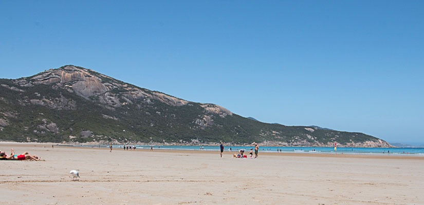
We’ve just added another great short trip destination to our getaway list – Wilsons Promontory National Park

We took off for a few days camping with 3 of our grandsons.

Wilsons Promontory is a place of spectacular scenery, pristine beaches, rainforests and heathlands, sand dunes and kilometres and kilometres of walking tracks.

Situated at the most southern point of mainland Australia, Wilsons Promontory National Park is only a 2½ hour drive from Melbourne CBD on bitumen roads all the way to Tidal River, the main camping area of the park.

The weather was hot on the first day so we chose the beach at Tidal River where it enters into Norman Bay. Here a long sweeping beach is bounded at each end by headlands. The sea surged gently towards shore with a wide shallow area that suited swimmers and paddlers of all ages – the younger and older generations amongst the breaking waves, toddlers and watchful parents playing in the shallows.

Picnic Bay, Wilsons PromontoryGood fun, but there was more to see, so after an ice cream from the General Store (where there was a long queue of similar-minded buyers) we headed for Squeaky Beach to see if we could find some squeaky sand.

We did find some squeaky sand, enough to satisfy all expectations and also found a smaller bay than Norman with less people and bigger waves.

The boys and their grandfather were soon in and so was their grandmother, enticed in by the crystal clear sea, the hot blue sky and water that turned out to be not too cold. (I don’t think I have been swimming at a beach for well over 20 years).

We all enjoyed it so much that we were back the next day.

There are many walks of varied lengths available for all abilities at Wilsons Promontory. Many of the walks involve overnight hikes, but we were only interested in short walks and there are many to choose from.

Our first choice was Lilly Pilly Nature Walk, an easy 5.2 kilometre stroll through heathland and eucalypt forest to a boardwalk loop in the creek gully rainforest. Of wildlife, there were birds, lizards and cicadas aplenty.

Big Drift walk was our other choice and a major hit with the boys. This walk is accessed from Stockyards camping area, found just inside the park entrance. The well Big drift sand dunes view, Wilsons Promontorysignposted walk is easy until the last 10 metres, which goes steeply up through very soft sand onto the top of the dunes. Was all that effort worth it?

Yes!

With views over the sea to the west and the mountains to the south, our boys had a great time exploring the expansive landscape of inland sand dunes revealed here.

We also visited Picnic Bay and viewed the nearby Whisky Bay. We could have spent more time at both these spots.

Car parking and toilets are provided at most sites. There is a huge camping area at Tidal River, but as summer time is very busy one needs to book online in June (the previous year) to get a site.

We didn’t book in June, instead we went to Yanakie Caravan Park on Corner Inlet and enjoyed ourselves there.  The caravan park is only 5 minutes from the park entrance and an easy drive to Tidal River and other places of the Prom.

All in all, Wilsons Promontory is an ideal place for a short trip getaway, with something to offer all the family.

Tasmania’s west coast – 4-wheel driving adventure
18/01/2019

Tasmania’s west coast – 4-wheel driving adventure

Anne Morton Australia, Tasmania 4wd adventure, 4wd travel, exploring, Tasmania's west coast 0

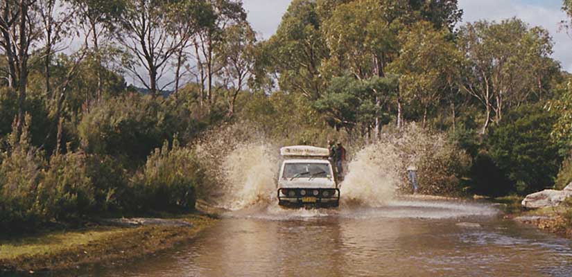
Tasmania’s west coast is a great place for a summer holiday. There is something here to please everyone, including walking trails, waterfalls, touring, history, taste experiences, fishing, bike riding and some great four-wheel driving.

There is a variety of terrain to four-wheel drive on, such as beaches, through rainforests, heathland and button grass plains.

We hopped on the ferry and joined a group for a tag-along tour of Tasmania’s west coast. They were a mixed group, mainly from New South Wales, well-known to each other and were ready for fun and adventure. And on this trip we had plenty of each.

Our west coast adventure began at Marawah from where we headed for the Arthur-Pieman Conservation Area and some of the best beach driving available in Australia.

Arthur River to Sandy Cape on Tasmania’s west coast

beach driving near Sandy Cape TasmaniaBut the best beach driving in Australia is also the most hazardous, so only experienced four-wheel drivers, travelling in well-equipped four-wheel drives, in company with a couple of other vehicles, should attempt this drive.

The beaches of the west coast of Tasmania are subject to the sometimes wild seas of the Southern Ocean with nothing between here and Africa. There can be a build-up of driftwood, foam to disguise hazards such as rocks, and reshaping of the sand to cause unexpected drop-offs across the beach.

There is also quicksand caused by the runoff into the sea from perch lakes higher up the beach and at the rivers as they enter into the sea. Walk these river mouths to check how firm the sand is, wait for the wave to recede and drive on over, one vehicle at a time is best.

With care and preparation there is much to enjoy on this spectacular coastline. For more information and an excellent video go to Tasmania’s Parks and Wildlife here.

We were lucky and found the beach to be dry and an amazing adventure. The only hazard we encountered was a low drop off of approximately 15 cm that was undetectable as we headed down the beach. Everything in the back of our truck bounced high, but otherwise it was a most enjoyable drive.

Balfour Track

From Sandy Cape we headed back towards Temma, then turned right onto the Balfour Track. This track is rated hard, due to the possibility of water covering a 70-metre canal-like stretch across the button grass plains. Under the water can be anything, including deep holes and rutted and slippery tracks.

As with using the Arthur-Pieman Conservation Area, permission is required from Parks and Wildlife available from the online Parks Shop.

Montezuma FallsMontezuma Falls Tasmania's west coast

Located not far from Zeehan, Montezuma Falls at 104 metres is one of Tasmania’s highest waterfalls. The track follows the historic route of the former North East Dundas Tramway. The tramway used to pass by the falls crossing the creek over a wooden trestle bridge.

The bridge is no more and neither is the tramway, but the remains of sleepers can be found in the track and in the fern-covered narrow cuttings through the rainforest of leatherwood, myrtle, sassafras and giant tree ferns.

The gauge of the tramway was only 2 feet which was quite narrow and chosen to suit the winding hillsides. Although flat, the track is slow to drive with care required through the narrow cuttings and windy nature of the track.

But the impressive Falls and swing bridge access, and the rainforest vegetation make this drive well worthwhile.

Saw Back Range Track to Adamsfield

Saw Back Range track TasmaniaThe Saw Back Range track is accessed from the Gordon River Road through a locked gate. The key must be obtained from the Parks Tasmania office at Mt Field National Park.

People using this route must be experienced four-wheel drivers with high clearance vehicles. The track can be very tricky, especially when wet and there is a steep and slippery section to negotiate very carefully.

But again, this is a beautiful drive through changing vegetation that switches from rainforest to heath. The track is often fringed by ferns and magnificent beech trees found in the rainforest.

In 1925 Adamsfield was the site of mining activity for osmiridium, which had a value about seven times that of gold in those days. Today there is little left of this once booming town as fires and reclaiming bush have left their mark.

Our DVD Tasmania: the Devil’s Playground includes all these tracks and shows each adventure and the fun we had getting there.

A perfect spot for a long weekend getaway camping
09/11/2016

A perfect spot for a long weekend getaway camping

Anne Morton Short trips Ararat, camping, exploring, weekend trips 0

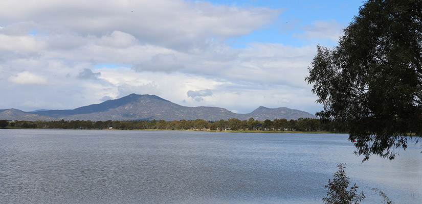
Camping at Langi Ghiran State Park, near Ararat, Victoria

It was a long weekend – where to go for our long weekend getaway?

‘What about Langi Ghiran State Park’ suggested Brother-in-law Soeren.

Where?

The idea was very enticing – only 2 hours from Melbourne, not far from Ararat, accessed from the Western Highway. We had often travelled that way when heading for the outback. We always made a beeline for Ararat for that first morning coffee, which was a reward for getting away and out of the city’s morning rush.

We had even seen the brown signs with the funny name as we sped past, and placed it on our ‘must go there one day’ list. For this long weekend getaway ‘one day’ had at last arrived.

Langi Ghiran is a small park featuring rugged granite peaks and gentle sloping woodlands. Aboriginal people of the Djab Wurrung have been connected to this land for thousands of years. There are driving and walking trails in the park and a very nice camping area.

Despite the unfavourable weather forecast, we hitched up the camper trailer and set off, turning from the Western Highway, 14 kilometres east of Ararat, where the brown sign for Langi Ghiran State Park pointed to a side road.

The camp site is located at the end of this road, tucked among the gum trees near a pretty waterfall on Easter Creek. The campsite was full of campers, when we arrived, but most soon disappeared – perhaps influenced by the weather forecast of strong winds and rain.

But for us it was an opportunity to relax over the long weekend with Naree and Soeren, to savour the bush, listen to birds singing, enjoy the long breaks of sunshine between rain clouds, especially after the wind subsided.

A campfire at Langi Ghiran State Park
The campfire at Langi Ghiran State Park

Now was the chance for bacon and eggs on muffins for breakfast. Not only that, but BIL even produced a wonderful lamb roast with potatoes and pumpkin cooked to perfection in the camp oven. I even made a damper, also baked in a camp oven. Well … it was a bit flat – more self-raising flour required? – but it went down all right while still warm.

There were other things to do near the campsite, such as explore the waterfall on Easter Creek. A walking trail followed the creek up to the smaller of the two reservoirs, while the 4wd Reservoir Track went up to the main reservoir at the top. Both reservoir walls were built from locally hewn granite blocks in 1880. The main reservoir supplied water to Ararat and still forms part of the system today.

Mt Buangor is a short drive back towards Ballarat and we found our way to Richards campsite and car park and the walk to Raglan Falls. At first this is an easy walk through the forest, but soon it climbs steeply following the creek upwards to the falls. There is also a lookout at the top of the falls. A most pleasant walk, but not to be taken lightly as it is quite steep and also slippery underfoot in several places.

There is also Rob Falls accessible from here, requiring a longer walk, and Fern Tree Waterfalls accessed from another road in Mt Buangor State Park.

The township of Ararat was only a short distance away, so we headed there to tour around J Ward, which was once a goal, then an asylum for the criminally insane.

A tour through J Ward is both challenging and enthralling and 90 minutes passed by very quickly. Our guide was very informative and this tour is well worth the small fee involved.

Ararat is a busy, bustling township with a history going back to the gold rush. There are many fine old buildings here and a historic guide is available from the Visitor Information Centre. Next time we might pick up the guide for an informative walking and driving tour.

There are many wineries in this area so we were happy to sample some reds at Fratin Brothers Vineyard.

Our long weekend was over so we packed up and headed home via Ballarat. John was keen to see if the house where his grandparents had lived was still there. Indeed it was and looking just as it had all those many years ago.

Lake Wendouree was close by, so we spent some time there, strolling around the Lake and then through the Botanic Gardens. After all the rain the Lake was a little full in some places and spilling over the walkways. The birds didn’t seem to mind, with Spring in full flight with pairs of black swans guarding or guiding their broods of fluffy cygnets.

But a very pleasant end to our long weekend away.

Popular Posts

  • Travels across Australia and back again
  • Blinman Mine Underground Experience
  • Caves to Caves Adventure in New South Wales
  • Phillip Island – family adventure playground
  • Following Explorers Burke and Wills: a Journey Across Australia

Categories

© Travel Videos of Australia 2023